
Make a donation
Gear up for your next adventure:
As an Amazon Associate, this site earns from qualifying purchases at no extra cost to you.
Wieda topographic map
Click on the map to display elevation.
Make a donation
Gear up for your next adventure:
As an Amazon Associate, this site earns from qualifying purchases at no extra cost to you.
Wieda
Die Wieda entspringt im niedersächsischen Teil des Harzes im Naturpark Harz. Ihr Ursprung liegt nördlich vom Stöberhai (ca. 720 m ü. NHN) im Westen des Tales Altes Loch: Dort fließen etwas oberhalb einer auf 540,6 m gelegenen Wegstelle zwei kurze Quellbäche auf etwa 545 m Höhe zusammen, die auf den Hochlagen des Berges entspringen und durch das Öhren- und Franzosental verlaufen. Anderen Angaben zufolge liegt Quelle des Flusses „nördlich des Berges Stöberhai“ auf etwa 580 m Höhe.
Make a donation
Gear up for your next adventure:
As an Amazon Associate, this site earns from qualifying purchases at no extra cost to you.
About this map
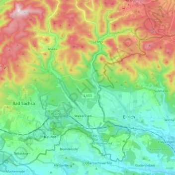
Name: Wieda topographic map, elevation, terrain.
Average elevation: 387 m
Minimum elevation: 218 m
Maximum elevation: 716 m
Make a donation
Gear up for your next adventure:
As an Amazon Associate, this site earns from qualifying purchases at no extra cost to you.
Other topographic maps
Click on a map to view its topography, its elevation and its terrain.