
Barmouth topographic map
Interactive map
Click on the map to display elevation.
About this map
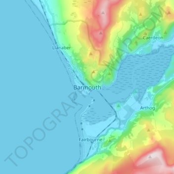
Name: Barmouth topographic map, elevation, terrain.
Location: Barmouth, Gwynedd, Pays de Galles, LL42 1EF, Royaume-Uni (52.68104 -4.09357 52.76104 -4.01357)
Average elevation: 95 m
Minimum elevation: -2 m
Maximum elevation: 543 m
Other topographic maps
Click on a map to view its topography, its elevation and its terrain.
Tyddyn-mynyddig
Royaume-Uni > Pays de Galles > Gwynedd > Bangor
Tyddyn-mynyddig, Bangor, Gwynedd, Pays de Galles, LL57 1NA, Royaume-Uni
Average elevation: 56 m