Geolocate

Aguazul topographic map

Click on the map to display elevation.

About this map

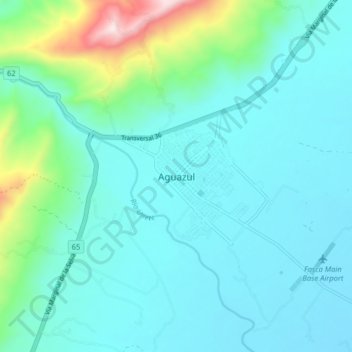
Name: Aguazul topographic map, elevation, terrain.

Location: Aguazul, Casanare, Colombia (5.13084 -72.59085 5.21084 -72.51085)

Average elevation: 357 m

Minimum elevation: 245 m

Maximum elevation: 931 m

Gear up for your next adventure:

🔭Outdoor Binoculars - Lightweight binoculars for birdwatching and hiking
🥤Collapsible Travel Cup - Saves space and weight in your mess kit
🔦LED Headlamp - Hands-free lighting for early morning starts or late finishes
🥾Waterproof Trail Shoes - Shoes designed to handle wet terrain
🗺️Topographic Maps - Detailed maps to explore trails, mountains, and wilderness areas

As an Amazon Associate, this site earns from qualifying purchases at no extra cost to you.