Geolocate

Pelverata topographic map

Click on the map to display elevation.

About this map

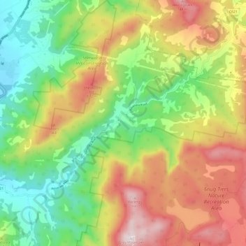
Name: Pelverata topographic map, elevation, terrain.

Location: Pelverata, Huon Valley, Tasmania, Australia (-43.09374 147.06777 -43.00701 147.17520)

Average elevation: 354 m

Minimum elevation: 0 m

Maximum elevation: 818 m

Other topographic maps

Click on a map to view its topography, its elevation and its terrain.

Frog Hill

Australia > Tasmania

Average elevation: 875 m

Mount Kate

Australia > Tasmania

Average elevation: 995 m

Tasman Peninsula

Australia > Tasmania > Tasman > Fortescue

Average elevation: 167 m

Mount Jukes

Australia > Tasmania

Average elevation: 773 m

Ulverstone

Australia > Tasmania > Ulverstone

Average elevation: 37 m

Bullock Hill

Australia > Tasmania > Grove

Average elevation: 147 m

Highland Waters

Australia > Tasmania > London Lakes

Average elevation: 759 m

Stillwater Hill

Australia > Tasmania

Average elevation: 353 m

Legges Tor

Australia > Tasmania

Average elevation: 1,457 m

Rowlands Hill

Australia > Tasmania

Average elevation: 388 m

Recherche Bay

Australia > Tasmania

Average elevation: 10 m

Bastyan Dam

Australia > Tasmania > Tullah

Average elevation: 233 m

Gear up for your next adventure:

🧢Beanie Hat - Keep your head warm in cold weather
Backpacking Tent - Lightweight tent for long-distance hiking trips
🧦Merino Wool Socks - Moisture-wicking comfort for long-distance hiking
🛶Kayak Accessories - Essential gear for safe and fun kayaking adventures
🧥Insulated Jacket - Keep warm in cold outdoor conditions

As an Amazon Associate, this site earns from qualifying purchases at no extra cost to you.