Geolocate

Fețeni topographic map

Click on the map to display elevation.

About this map

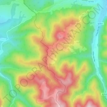
Name: Fețeni topographic map, elevation, terrain.

Location: Fețeni, Cugir, Alba, 515604, Romania (45.78544 23.32643 45.82544 23.36643)

Average elevation: 519 m

Minimum elevation: 316 m

Maximum elevation: 779 m

Gear up for your next adventure:

🛏️Sleeping Bag - Warm and compact sleeping bags for outdoor camping
🪑Ultralight Camping Stool - Compact seating for rest stops during long hikes
🕶️Polarized Sunglasses - Protect your eyes with durable polarized lenses
🧢Hiking Sun Hat - Wide-brimmed protection for exposed mountain ridges
🥾Waterproof Hiking Boots - Boots keeping your feet dry in wet conditions

As an Amazon Associate, this site earns from qualifying purchases at no extra cost to you.