
Stupava topographic map
Click on the map to display elevation.
Stupava
The town is located in the Záhorie lowland, under the Little Carpathians, around 15 km (9 mi) north of Bratislava at an altitude of 182 metres. It has 15, 095 inhabitants as of 2021 and has a land area of 67.17 km2 (26 sq mi). Apart from the core part of the city, Mást (German: Maaßt, Hungarian: Mászt), located just south of the core part of the city, is another part of Stupava. It has been initially a separate village with ethnic Croatian majority, which was formally annexed by Stupava in 1953.
About this map
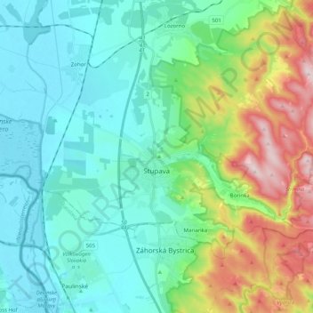
Name: Stupava topographic map, elevation, terrain.
Average elevation: 237 m
Minimum elevation: 137 m
Maximum elevation: 540 m