Geolocate

Hector topographic map

Click on the map to display elevation.

About this map

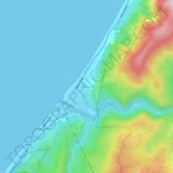
Name: Hector topographic map, elevation, terrain.

Location: Hector, Buller District, West Coast, New Zealand (-41.62334 171.86346 -41.58334 171.90346)

Average elevation: 109 m

Minimum elevation: -3 m

Maximum elevation: 485 m

Other topographic maps

Click on a map to view its topography, its elevation and its terrain.

Karamea River

New Zealand > West Coast > Buller District

Average elevation: 752 m

Lake Daniell

New Zealand > West Coast > Buller District

Average elevation: 751 m

Heaphy River

New Zealand > West Coast > Buller District

Average elevation: 626 m

Brunner Range

New Zealand > West Coast > Buller District

Average elevation: 728 m

Peel Range

New Zealand > West Coast > Buller District

Average elevation: 1,101 m

Matiri Range

New Zealand > West Coast > Buller District

Average elevation: 754 m

Lyell Range

New Zealand > West Coast > Buller District

Average elevation: 580 m

Gear up for your next adventure:

Lightweight Camping Tent - Portable shelter optimized for Canadian backcountry camping
🧦Hiking Socks - Moisture-wicking and comfortable socks for long hikes
🥽Outdoor Goggles - Protective eyewear for outdoor activities
🧴Sunscreen SPF - Broad-spectrum sunscreen for outdoor activities
🛁Quick-Dry Microfiber Towel - Space-saving towel that dries rapidly on the move

As an Amazon Associate, this site earns from qualifying purchases at no extra cost to you.