
Liencres topographic map
Click on the map to display elevation.
Liencres
Liencres es una localidad costera de Cantabria (España), perteneciente al municipio de Piélagos. Está situada en el litoral a 9 kilómetros al oeste de Santander, con una altitud de 72 metros sobre el nivel del mar.
About this map
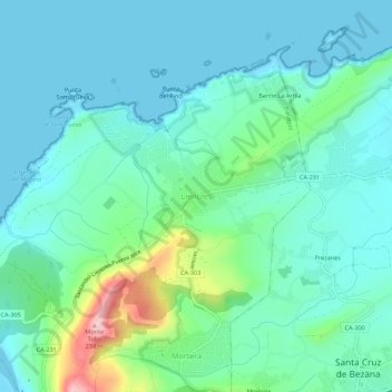
Name: Liencres topographic map, elevation, terrain.
Location: Liencres, Piélagos, Cantabria, 39120, España (43.44047 -3.94762 43.48047 -3.90762)
Average elevation: 43 m
Minimum elevation: 0 m
Maximum elevation: 212 m
Other topographic maps
Click on a map to view its topography, its elevation and its terrain.