
Make a donation
Gear up for your next adventure:
As an Amazon Associate, this site earns from qualifying purchases at no extra cost to you.
Andelfingen topographic map
Click on the map to display elevation.
Make a donation
Gear up for your next adventure:
As an Amazon Associate, this site earns from qualifying purchases at no extra cost to you.
Andelfingen
Langenenslingen liegt am Nordrand Oberschwabens im Altmoränenland. Der niedrigstgelegene Punkt befindet sich mit 549 m Höhe am Biberbach bei Andelfingen, der höchstgelegene, der auch der höchste des Landkreises Biberach ist, auf dem Rotreiß mit 800,8 m Höhe. Langenenslingen ist die flächengrößte sowie die waldreichste Gemeinde des Landkreises Biberach.
Make a donation
Gear up for your next adventure:
As an Amazon Associate, this site earns from qualifying purchases at no extra cost to you.
About this map
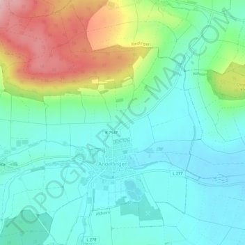
Name: Andelfingen topographic map, elevation, terrain.
Average elevation: 595 m
Minimum elevation: 537 m
Maximum elevation: 743 m
Make a donation
Gear up for your next adventure:
As an Amazon Associate, this site earns from qualifying purchases at no extra cost to you.