
Make a donation
Gear up for your next adventure:
As an Amazon Associate, this site earns from qualifying purchases at no extra cost to you.
Krewinkel topographic map
Click on the map to display elevation.
Make a donation
Gear up for your next adventure:
As an Amazon Associate, this site earns from qualifying purchases at no extra cost to you.
Krewinkel
Diepenlinchen ist ein nördlicher Ortsteil von Mausbach. Es liegt östlich des Waldstücks Wolfshecke auf etwa 290 m Höhe. Direkt nordöstlich befindet sich ein Gewerbegebiet und jenseits davon das Segelfluggelände Stolberg-Diepenlinchen.
Make a donation
Gear up for your next adventure:
As an Amazon Associate, this site earns from qualifying purchases at no extra cost to you.
About this map
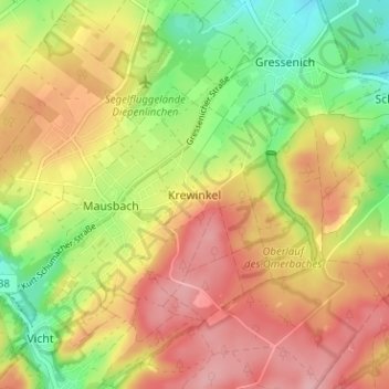
Name: Krewinkel topographic map, elevation, terrain.
Average elevation: 271 m
Minimum elevation: 201 m
Maximum elevation: 332 m
Make a donation
Gear up for your next adventure:
As an Amazon Associate, this site earns from qualifying purchases at no extra cost to you.
Other topographic maps
Click on a map to view its topography, its elevation and its terrain.
52223
Deutschland > Nordrhein-Westfalen > Städteregion Aachen > Stolberg > Dorff
Average elevation: 253 m