Geolocate

Mabato topographic map

Click on the map to display elevation.

About this map

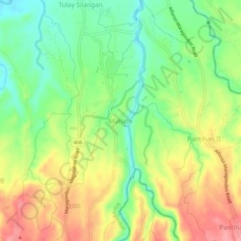
Name: Mabato topographic map, elevation, terrain.

Location: Mabato, Maragondon, Cavite, Calabarzon, 4112, Philippines (14.22598 120.76031 14.26598 120.80031)

Average elevation: 71 m

Minimum elevation: 25 m

Maximum elevation: 124 m

Other topographic maps

Click on a map to view its topography, its elevation and its terrain.

Maragondon River

Philippines > Cavite > Maragondon > Bucal III-B

Average elevation: 28 m

Patungan

Philippines > Cavite > Maragondon

Average elevation: 102 m

Patungan

Philippines > Cavite > Maragondon

Average elevation: 114 m

Gear up for your next adventure:

Camping Groundsheet - Protect your tent from moisture and dirt
🥾Trail Hiking Socks - Comfortable socks to prevent blisters and fatigue
Bushcraft Tarp - Versatile emergency shelter or gear protection
🧢Sun Protection Cap - Breathable cap to protect from sun exposure
🚲Heavy Duty Bike Lock - Secure your bike at the trailhead or during stops

As an Amazon Associate, this site earns from qualifying purchases at no extra cost to you.