Geolocate

Berbek topographic map

Click on the map to display elevation.

About this map

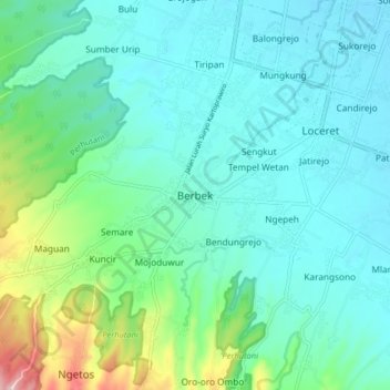
Name: Berbek topographic map, elevation, terrain.

Location: Berbek, Nganjuk, East Java, Java, 64473, Indonesia (-7.70010 111.82663 -7.62010 111.90663)

Average elevation: 107 m

Minimum elevation: 55 m

Maximum elevation: 315 m

Other topographic maps

Click on a map to view its topography, its elevation and its terrain.

Ngronggot

Indonesia > East Java > Nganjuk

Average elevation: 50 m

Kaloran

Indonesia > East Java > Nganjuk

Average elevation: 46 m

Ngronggot

Indonesia > East Java > Nganjuk

Average elevation: 51 m

Kelurahan

Indonesia > East Java > Nganjuk

Average elevation: 47 m

Banjarsari

Indonesia > East Java > Nganjuk

Average elevation: 49 m

Gear up for your next adventure:

🩹Compact First Aid Kit - Pre-packed essentials for common trail injuries
🥾Durable Hiking Shoes - Long-lasting shoes for frequent hiking
🔥Emergency Fire Starter - Reliable ignition source for all weather conditions
🥾Waterproof Trail Shoes - Shoes designed to handle wet terrain
🦶Anti-Blister Balm - Prevents friction and hotspots during long ascents

As an Amazon Associate, this site earns from qualifying purchases at no extra cost to you.