
Thank you for supporting this site ❤️
Make a donation
Make a donation
Gear up for your next adventure:
As an Amazon Associate, this site earns from qualifying purchases at no extra cost to you.
Kanor topographic map
Click on the map to display elevation.
Thank you for supporting this site ❤️
Make a donation
Make a donation
Gear up for your next adventure:
As an Amazon Associate, this site earns from qualifying purchases at no extra cost to you.
Kanor
Kanore is located at 24°26′N 74°16′E / 24.43°N 74.27°E / 24.43; 74.27. It has an average elevation of 469 metres (1,539 ft).
Thank you for supporting this site ❤️
Make a donation
Make a donation
Gear up for your next adventure:
As an Amazon Associate, this site earns from qualifying purchases at no extra cost to you.
About this map
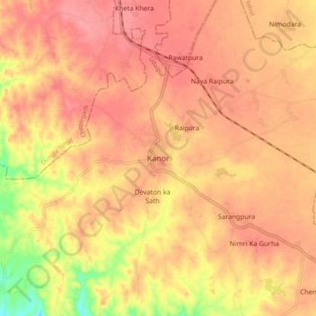
Name: Kanor topographic map, elevation, terrain.
Location: Kanor, Vallabhnagar Tehsil, Udaipur, Rajasthan, India (24.39366 74.22469 24.47366 74.30469)
Average elevation: 476 m
Minimum elevation: 417 m
Maximum elevation: 500 m
Thank you for supporting this site ❤️
Make a donation
Make a donation
Gear up for your next adventure:
As an Amazon Associate, this site earns from qualifying purchases at no extra cost to you.