
Neda topographic map
Interactive map
Click on the map to display elevation.
About this map
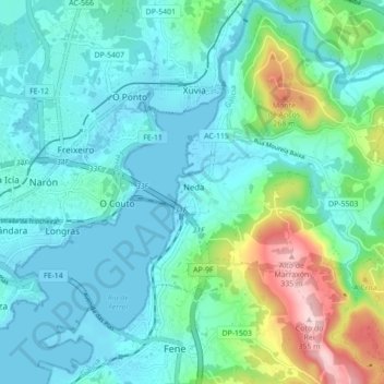
Name: Neda topographic map, elevation, terrain.
Location: Neda, Ferrol, La Coruña, Galicia, España (43.46783 -8.17013 43.53091 -8.08864)
Average elevation: 69 m
Minimum elevation: -3 m
Maximum elevation: 345 m
Other topographic maps
Click on a map to view its topography, its elevation and its terrain.
Río Belelle
Río Belelle, Neda, Ferrol (Comarca), A Coruña, Galicia, 15510, España
Average elevation: 137 m