
Make a donation
Gear up for your next adventure:
As an Amazon Associate, this site earns from qualifying purchases at no extra cost to you.
Aroroy topographic map
Click on the map to display elevation.
Make a donation
Gear up for your next adventure:
As an Amazon Associate, this site earns from qualifying purchases at no extra cost to you.
About this map
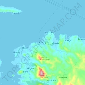
Name: Aroroy topographic map, elevation, terrain.
Location: Aroroy, Masbate, Bicol Region, Philippines (12.47233 123.35869 12.55233 123.43869)
Average elevation: 29 m
Minimum elevation: -1 m
Maximum elevation: 311 m
Make a donation
Gear up for your next adventure:
As an Amazon Associate, this site earns from qualifying purchases at no extra cost to you.
Other topographic maps
Click on a map to view its topography, its elevation and its terrain.
Make a donation
Gear up for your next adventure:
As an Amazon Associate, this site earns from qualifying purchases at no extra cost to you.
Jintotolo Island
Philippines > Masbate > Jintotolo
Its elevation was recorded at around 120 feet (37 m) in 1919. A lighthouse with a tower at 51 feet (16 m) in height exists on Jintotolo island.
Average elevation: 6 m
Make a donation
Gear up for your next adventure:
As an Amazon Associate, this site earns from qualifying purchases at no extra cost to you.
Make a donation
Gear up for your next adventure:
As an Amazon Associate, this site earns from qualifying purchases at no extra cost to you.