Geolocate

Braunau am Inn topographic map

Click on the map to display elevation.

About this map

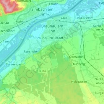
Name: Braunau am Inn topographic map, elevation, terrain.

Location: Braunau am Inn, Bezirk Braunau, Upper Austria, 5280, Austria (48.20024 12.95198 48.26933 13.07385)

Average elevation: 372 m

Minimum elevation: 333 m

Maximum elevation: 503 m

Other topographic maps

Click on a map to view its topography, its elevation and its terrain.

Rudersberg

Austria > Upper Austria > Bezirk Braunau

Average elevation: 500 m

Friedburg

Austria > Upper Austria > Bezirk Braunau

Average elevation: 557 m

Winham

Austria > Upper Austria > Bezirk Braunau > Tarsdorf

Average elevation: 456 m

Gear up for your next adventure:

💡Portable Camping Lamp - Rechargeable lamp for campsite lighting
🧥Thermal Fleece Jacket - Versatile insulation for changing mountain temperatures
🦟Insect Repellent - Keep mosquitoes and black flies away in wooded areas
🏃Hydration Running Vest - Carry water and maps close to your body for speed
🪑Insulated Seat Pad - Protect your seat from cold rocks and wet logs

As an Amazon Associate, this site earns from qualifying purchases at no extra cost to you.