
Gunung Perak topographic map
Interactive map
Click on the map to display elevation.
About this map
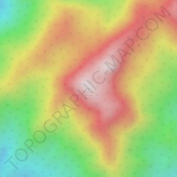
Name: Gunung Perak topographic map, elevation, terrain.
Location: Gunung Perak, Pendang, Kedah, Malaysia (5.96436 100.63672 5.96446 100.63682)
Average elevation: 548 m
Minimum elevation: 199 m
Maximum elevation: 839 m
Other topographic maps
Click on a map to view its topography, its elevation and its terrain.
Kampung Manggol
Kampung Manggol, Jitra, Kubang Pasu, Kedah, 06000, Malaysia
Average elevation: 11 m
Kampung Baru Batu 8
Malaysia > Kedah > Kulim > Kampung Baru Batu 8
Kampung Baru Batu 8, Kulim, Kedah, Malaysia
Average elevation: 53 m
Kampung Bukit
Malaysia > Kedah > Kampung Bukit
Kampung Bukit, Pokok Sena, Kedah, 06350, Malaysia
Average elevation: 34 m
Alor Setar
Malaysia > Kedah > Alor Setar
Alor Setar, Kota Setar, Kedah, 05672, Malaysia
Average elevation: 9 m
Kuala Nerang
Malaysia > Kedah > Kuala Nerang
Kuala Nerang, Padang Terap, Kedah, 06300, Malaysia
Average elevation: 32 m