
Thank you for supporting this site ❤️
Make a donation
Make a donation
Gear up for your next adventure:
As an Amazon Associate, this site earns from qualifying purchases at no extra cost to you.
Luengas topographic map
Click on the map to display elevation.
Thank you for supporting this site ❤️
Make a donation
Make a donation
Gear up for your next adventure:
As an Amazon Associate, this site earns from qualifying purchases at no extra cost to you.
About this map
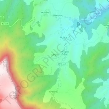
Name: Luengas topographic map, elevation, terrain.
Location: Luengas, Valle de Mena, Burgos, Castilla y León, España (43.07164 -3.21889 43.11164 -3.17889)
Average elevation: 534 m
Minimum elevation: 276 m
Maximum elevation: 1,092 m
Thank you for supporting this site ❤️
Make a donation
Make a donation
Gear up for your next adventure:
As an Amazon Associate, this site earns from qualifying purchases at no extra cost to you.