
Town Centre Park topographic map
Interactive map
Click on the map to display elevation.
About this map
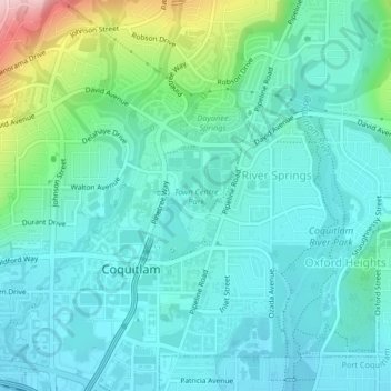
Name: Town Centre Park topographic map, elevation, terrain.
Average elevation: 62 m
Minimum elevation: 13 m
Maximum elevation: 256 m
Metro Vancouver Regional District trails, hiking, mountain biking, running and outdoor activities
Other topographic maps
Click on a map to view its topography, its elevation and its terrain.
Coquitlam
Canada > British Columbia > Metro Vancouver Regional District > Coquitlam
Southwest Coquitlam comprises the original core of the city, with Maillardville and Fraser River industrial sector giving way to the large residential areas of Austin Heights, colloquially referred to as "The Bump" due to its high and flat plateau topography. These older residences, with larger property…
Average elevation: 230 m