
Make a donation
Gear up for your next adventure:
As an Amazon Associate, this site earns from qualifying purchases at no extra cost to you.
Vorbexten topographic map
Click on the map to display elevation.
Make a donation
Gear up for your next adventure:
As an Amazon Associate, this site earns from qualifying purchases at no extra cost to you.
About this map
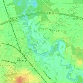
Name: Vorbexten topographic map, elevation, terrain.
Average elevation: 35 m
Minimum elevation: 21 m
Maximum elevation: 58 m
Make a donation
Gear up for your next adventure:
As an Amazon Associate, this site earns from qualifying purchases at no extra cost to you.
Other topographic maps
Click on a map to view its topography, its elevation and its terrain.
Salzbergen
Deutschland > Niedersachsen > Landkreis Emsland > Salzbergen
Das 1993 eröffnete Feuerwehrmuseum Salzbergen zeigt Feuerwehrexponate aus aller Welt. Der Feuerwehrmuseumsverein verfügt über eine Anzahl von Fahrzeugen, Handdruckspritzen, Geräten und Kleinteilen. Unter anderem sind Helme aus aller Welt, Kappen und Mützen, Uniformen, Ärmelabzeichen, Orden und…
Average elevation: 39 m