Geolocate

Becerril topographic map

Click on the map to display elevation.

About this map

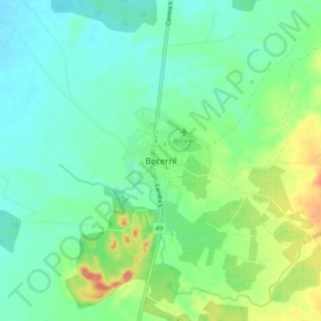
Name: Becerril topographic map, elevation, terrain.

Location: Becerril, Cesar, Colombia (9.66328 -73.31861 9.74328 -73.23861)

Average elevation: 111 m

Minimum elevation: 86 m

Maximum elevation: 174 m

Gear up for your next adventure:

🧶550 Survival Paracord - Versatile utility cord for emergency repairs and rigging
🥾Trekking Boots - Durable boots for long-distance trekking
🏕️Camping Hammock - Integrated protection for sleeping between trees
🧥Softshell Jacket - Windproof and breathable jacket for hiking
🥾Mountain Hiking Shoes - Shoes with superior grip for mountainous terrain

As an Amazon Associate, this site earns from qualifying purchases at no extra cost to you.