
Mernes topographic map
Click on the map to display elevation.
About this map
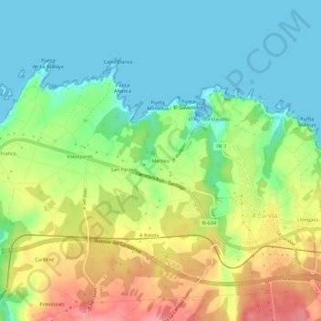
Name: Mernes topographic map, elevation, terrain.
Location: Mernes, El Franco, Asturias, 33746, España (43.53778 -6.86692 43.57778 -6.82692)
Average elevation: 38 m
Minimum elevation: -1 m
Maximum elevation: 101 m
Other topographic maps
Click on a map to view its topography, its elevation and its terrain.
Villalmarzo
La aldea se sitúa a una altitud de 200 m y dista 7,5 km de la villa de La Caridad, capital del concejo.
Average elevation: 186 m