
Thank you for supporting this site ❤️
Make a donation
Make a donation
Gear up for your next adventure:
As an Amazon Associate, this site earns from qualifying purchases at no extra cost to you.
Höhr topographic map
Click on the map to display elevation.
Thank you for supporting this site ❤️
Make a donation
Make a donation
Gear up for your next adventure:
As an Amazon Associate, this site earns from qualifying purchases at no extra cost to you.
About this map
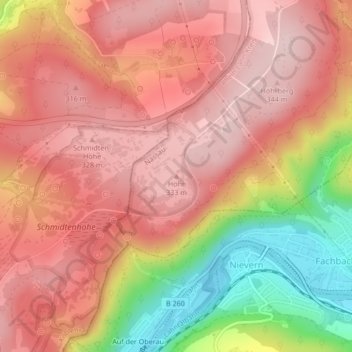
Name: Höhr topographic map, elevation, terrain.
Average elevation: 252 m
Minimum elevation: 69 m
Maximum elevation: 348 m
Thank you for supporting this site ❤️
Make a donation
Make a donation
Gear up for your next adventure:
As an Amazon Associate, this site earns from qualifying purchases at no extra cost to you.
Other topographic maps
Click on a map to view its topography, its elevation and its terrain.
56112
Deutschland > Rheinland-Pfalz > Rhein-Lahn-Kreis > Lahnstein > Friedland
Average elevation: 162 m
56112
Deutschland > Rheinland-Pfalz > Rhein-Lahn-Kreis > Lahnstein > Friedland
Average elevation: 177 m