
Thank you for supporting this site ❤️
Make a donation
Make a donation
Gear up for your next adventure:
As an Amazon Associate, this site earns from qualifying purchases at no extra cost to you.
Fort Wright topographic map
Click on the map to display elevation.
Thank you for supporting this site ❤️
Make a donation
Make a donation
Gear up for your next adventure:
As an Amazon Associate, this site earns from qualifying purchases at no extra cost to you.
About this map
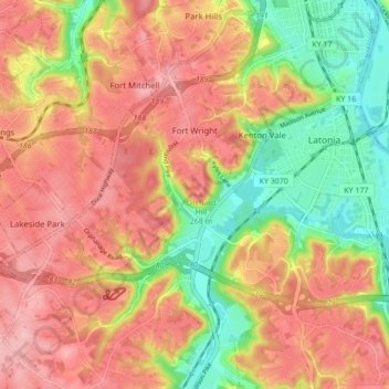
Name: Fort Wright topographic map, elevation, terrain.
Location: Fort Wright, Kenton County, Kentucky, United States (39.00704 -84.55931 39.07417 -84.51141)
Average elevation: 219 m
Minimum elevation: 139 m
Maximum elevation: 279 m
Thank you for supporting this site ❤️
Make a donation
Make a donation
Gear up for your next adventure:
As an Amazon Associate, this site earns from qualifying purchases at no extra cost to you.
Other topographic maps
Click on a map to view its topography, its elevation and its terrain.
Daniel Carter Beard Boyhood Home
United States > Kentucky > Kenton County > Covington
Average elevation: 157 m