
Make a donation
Gear up for your next adventure:
As an Amazon Associate, this site earns from qualifying purchases at no extra cost to you.
Lengde topographic map
Click on the map to display elevation.
Make a donation
Gear up for your next adventure:
As an Amazon Associate, this site earns from qualifying purchases at no extra cost to you.
Lengde
Lengde liegt nördlich des Harly-Walds auf einer Höhe von 129 m ü. NHN und unmittelbar an der Bundesautobahn 36. Der Ortsteil Vienenburg liegt etwa 5,5 km südlich von Lengde, das Zentrum Goslars etwa 14 km südwestlich. Gegenwärtig hat Lengde rund 600 Einwohner.
Make a donation
Gear up for your next adventure:
As an Amazon Associate, this site earns from qualifying purchases at no extra cost to you.
About this map
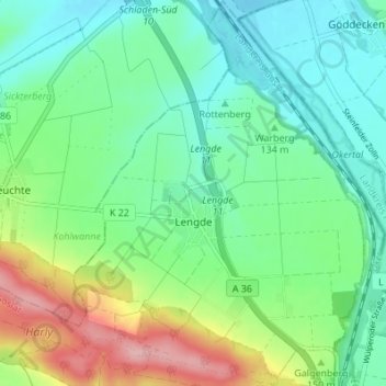
Name: Lengde topographic map, elevation, terrain.
Location: Lengde, Goslar, Landkreis Goslar, Niedersachsen, Deutschland (51.96390 10.53175 52.00593 10.58311)
Average elevation: 142 m
Minimum elevation: 99 m
Maximum elevation: 243 m
Make a donation
Gear up for your next adventure:
As an Amazon Associate, this site earns from qualifying purchases at no extra cost to you.
Other topographic maps
Click on a map to view its topography, its elevation and its terrain.
Kaiserpfalz Goslar
Deutschland > Niedersachsen > Landkreis Goslar > Goslar
Die Ursprünge der Kaiserpfalz liegen vermutlich in einem königlichen Jagdhof, wie ihn Adam von Bremen für die ottonische Zeit erwähnte. Bereits Heinrich II. hatte um 1005 einen ersten Pfalzbau in Goslar errichten lassen, der, sicher aufgrund der reichen Erzfunde des nahen Rammelsbergs, der unweit gelegenen…
Average elevation: 323 m
Make a donation
Gear up for your next adventure:
As an Amazon Associate, this site earns from qualifying purchases at no extra cost to you.
Bocksberg
Deutschland > Niedersachsen > Landkreis Goslar > Goslar
Die Bocksberg-Seilbahn ist eine 1100 m lange, 1970 von der Pohlig-Heckel-Bleichert Vereinigte Maschinenfabriken AG (PHB) erbaute Gondelbahn mit Kleinkabinen für jeweils vier Personen. Mit 164 m Höhenunterschied führt sie von Hahnenklee (560 m) auf den Bocksberg und kann pro Stunde derzeit 600 Fahrgäste…
Average elevation: 602 m
Granetalsperre
Deutschland > Niedersachsen > Landkreis Goslar > Goslar > Astfeld
Der Staudamm wurde von 1966 bis 1969 aufgeschüttet. Er ist über der Talsohle 62 m und über der Gründungssohle 67 m hoch. Der Damm ist an der auf 313 m Höhe liegenden Krone 600 m lang und 8 m breit; an seiner Basis sind es 234 m Breite. Der Damm besteht aus 1,8 Mio. m³ Erdmaterial, und er hat eine…
Average elevation: 360 m