Geolocate

Fondi topographic map

Click on the map to display elevation.

About this map
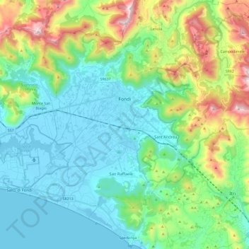
Name: Fondi topographic map, elevation, terrain.

Location: Fondi, Latina, Lazio, 04022, Italy (41.27365 13.28113 41.40465 13.51276)

Average elevation: 261 m

Minimum elevation: -3 m

Maximum elevation: 1,044 m

Other topographic maps

Click on a map to view its topography, its elevation and its terrain.

Borgo Bainsizza

Italy > Lazio > Latina > Latina

Average elevation: 27 m

Le Cupe

Italy > Lazio > Latina > Itri

Average elevation: 318 m

Campoleone Scalo

Italy > Lazio > Latina > Aprilia

Average elevation: 124 m

Gear up for your next adventure:

🥾Hiking Leggings - Comfortable leggings for outdoor activities
⛺Lightweight Camping Tent - Portable shelter optimized for Canadian backcountry camping
💡Compact LED Flashlight - Powerful and portable flashlight for outdoor use
👟Leg Gaiters - Keep debris, mud, and snow out of your boots
💡Solar Camping Lamp - Eco-friendly lighting for campsites

As an Amazon Associate, this site earns from qualifying purchases at no extra cost to you.