Geolocate

Centerville topographic map

Click on the map to display elevation.

About this map

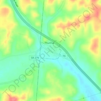
Name: Centerville topographic map, elevation, terrain.

Location: Centerville, Gallia County, Ohio, United States (38.89570 -82.44926 38.90040 -82.44180)

Average elevation: 221 m

Minimum elevation: 191 m

Maximum elevation: 262 m

Other topographic maps

Click on a map to view its topography, its elevation and its terrain.

Rodney

United States > Ohio > Gallia County

Average elevation: 215 m

Porter

United States > Ohio > Gallia County

Average elevation: 222 m

Northup

United States > Ohio > Gallia County

Average elevation: 204 m

Mercerville

United States > Ohio > Gallia County

Average elevation: 245 m

Kerr

United States > Ohio > Gallia County

Average elevation: 205 m

Harrisburg

United States > Ohio > Gallia County

Average elevation: 205 m

Gallia

United States > Ohio > Gallia County

Average elevation: 224 m

Evergreen

United States > Ohio > Gallia County

Average elevation: 219 m

Ewington

United States > Ohio > Gallia County

Average elevation: 210 m

Centerpoint

United States > Ohio > Gallia County

Average elevation: 235 m

Adamsville

United States > Ohio > Gallia County

Average elevation: 203 m

Kanauga

United States > Ohio > Gallia County

Average elevation: 187 m

Bidwell

United States > Ohio > Gallia County

Average elevation: 216 m

Kyger

United States > Ohio > Gallia County

Average elevation: 220 m

Bulaville

United States > Ohio > Gallia County

Average elevation: 206 m

Gear up for your next adventure:

🔦LED Headtorch - Bright and durable light for night activities
🥾Waterproof Trail Shoes - Shoes designed to handle wet terrain
🛌Insulated Sleeping Pad - Critical thermal barrier between you and the cold ground
🚑Survival Whistle - Signal for help across long distances in mountains
🧰Multitool Knife - Compact and versatile tool for outdoor use

As an Amazon Associate, this site earns from qualifying purchases at no extra cost to you.