Geolocate

Cileles topographic map

Click on the map to display elevation.

About this map

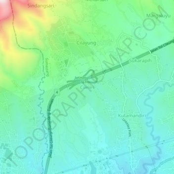
Name: Cileles topographic map, elevation, terrain.

Location: Cileles, Sumedang, West Java, Java, 45363, Indonesia (-6.93183 107.75741 -6.89183 107.79741)

Average elevation: 824 m

Minimum elevation: 693 m

Maximum elevation: 1,056 m

Other topographic maps

Click on a map to view its topography, its elevation and its terrain.

Situ II ITB

Indonesia > West Java > Sumedang > Jatinangor

Average elevation: 726 m

Gear up for your next adventure:

🥾Mountaineering Boots - Supportive boots for climbing and high-altitude hiking
💧Reusable Water Bottle - Durable water bottles for hydration on trails
🥾Trekking Poles - Adjustable trekking poles to reduce knee stress and improve stability
🧢Outdoor Visor - Breathable visor for sunny hikes
💡Compact LED Flashlight - Powerful and portable flashlight for outdoor use

As an Amazon Associate, this site earns from qualifying purchases at no extra cost to you.