Geolocate

Taranna topographic map

Click on the map to display elevation.

About this map

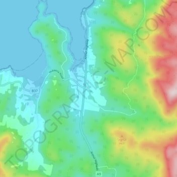
Name: Taranna topographic map, elevation, terrain.

Location: Taranna, Tasman, Tasmania, 7180, Australia (-43.09620 147.83592 -43.03068 147.89490)

Average elevation: 127 m

Minimum elevation: -1 m

Maximum elevation: 484 m

Other topographic maps

Click on a map to view its topography, its elevation and its terrain.

White Beach

Australia > Tasmania > Tasman > White Beach

Average elevation: 45 m

Cape Pillar

Australia > Tasmania > Tasman

Average elevation: 18 m

Tasman Island

Australia > Tasmania > Tasman

Average elevation: 19 m

Tasman Peninsula

Australia > Tasmania > Tasman > Fortescue

Average elevation: 167 m

Simmonds Hill

Australia > Tasmania > Tasman

Average elevation: 189 m

Gear up for your next adventure:

🥾Hiking Shoes - Durable and comfortable shoes for trail hiking
🗺️Topographic Maps - Detailed maps to explore trails, mountains, and wilderness areas
💧Reusable Water Bottle - Durable water bottles for hydration on trails
🧴Insect Repellent - Protect yourself from bugs during outdoor adventures
🧴Outdoor Sunscreen - High SPF protection for high-altitude UV exposure

As an Amazon Associate, this site earns from qualifying purchases at no extra cost to you.