
Make a donation
Gear up for your next adventure:
As an Amazon Associate, this site earns from qualifying purchases at no extra cost to you.
Mangalagiri topographic map
Click on the map to display elevation.
Make a donation
Gear up for your next adventure:
As an Amazon Associate, this site earns from qualifying purchases at no extra cost to you.
Mangalagiri
Mangalagiri is located at 16°26′N 80°33′E / 16.43°N 80.55°E / 16.43; 80.55. It has an average elevation of 29.08 m (95.4 ft).It is located 26 kilometres (16 mi) north east of the district headquarters, Guntur, and just 10 km (6.2 mi) south west of Vijayawada and also 30 km (19 mi) to the north west of Tenali by road. It lies on hilly terrain. It falls under Seismic Zone 3.
Make a donation
Gear up for your next adventure:
As an Amazon Associate, this site earns from qualifying purchases at no extra cost to you.
About this map
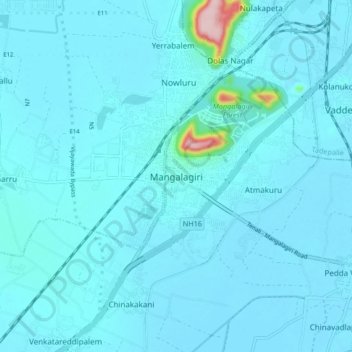
Name: Mangalagiri topographic map, elevation, terrain.
Location: Mangalagiri, Guntur, Andhra Pradesh, 522500, India (16.39182 80.52881 16.47182 80.60881)
Average elevation: 29 m
Minimum elevation: 15 m
Maximum elevation: 245 m
Make a donation
Gear up for your next adventure:
As an Amazon Associate, this site earns from qualifying purchases at no extra cost to you.