Geolocate

Atarau topographic map

Click on the map to display elevation.

About this map

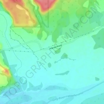
Name: Atarau topographic map, elevation, terrain.

Location: Atarau, Grey District, West Coast, 7843, New Zealand (-42.34835 171.48017 -42.32835 171.50017)

Average elevation: 59 m

Minimum elevation: 39 m

Maximum elevation: 121 m

Other topographic maps

Click on a map to view its topography, its elevation and its terrain.

Arnold River

New Zealand > West Coast > Grey District > Moana

Average elevation: 153 m

Lake Haupiri

New Zealand > West Coast > Grey District

Average elevation: 223 m

Lake Avernus

New Zealand > West Coast > Grey District

Average elevation: 1,335 m

Gear up for your next adventure:

🧭GPS Tracker - Track your location in remote areas safely
🦯Trekking Poles - Reduced impact on joints for steep topographic climbs
🛶Canoe Life Vest - Safety vest for water sports
🥾Trekking Boots - Durable boots for long-distance trekking
💡LED Camping Lantern - Illuminate your campsite with long-lasting lanterns

As an Amazon Associate, this site earns from qualifying purchases at no extra cost to you.