
Make a donation
Gear up for your next adventure:
As an Amazon Associate, this site earns from qualifying purchases at no extra cost to you.
Cristóbal topographic map
Click on the map to display elevation.
Make a donation
Gear up for your next adventure:
As an Amazon Associate, this site earns from qualifying purchases at no extra cost to you.
About this map
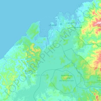
Name: Cristóbal topographic map, elevation, terrain.
Location: Cristóbal, Distrito Colón, Colón, Panamá (9.11119 -80.04493 9.40565 -79.65618)
Average elevation: 46 m
Minimum elevation: -2 m
Maximum elevation: 438 m
Make a donation
Gear up for your next adventure:
As an Amazon Associate, this site earns from qualifying purchases at no extra cost to you.
Other topographic maps
Click on a map to view its topography, its elevation and its terrain.
Fuerte Sherman
Panamá > Colón > Distrito Colón > Cristóbal
Entre 1966 y 1979, se lanzaron 1.160 cohetes con una altitud máxima de vuelo de 99 kilómetros desde Fort Sherman.
Average elevation: 7 m