
Make a donation
Gear up for your next adventure:
As an Amazon Associate, this site earns from qualifying purchases at no extra cost to you.
Josie topographic map
Click on the map to display elevation.
Make a donation
Gear up for your next adventure:
As an Amazon Associate, this site earns from qualifying purchases at no extra cost to you.
About this map
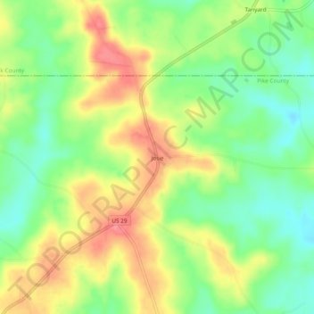
Name: Josie topographic map, elevation, terrain.
Location: Josie, Pike County, Alabama, United States (31.84988 -85.73883 31.88988 -85.69883)
Average elevation: 149 m
Minimum elevation: 111 m
Maximum elevation: 192 m
Make a donation
Gear up for your next adventure:
As an Amazon Associate, this site earns from qualifying purchases at no extra cost to you.
Other topographic maps
Click on a map to view its topography, its elevation and its terrain.
Troy
United States > Alabama > Pike County
Troy is located at 31°48′32″N 85°58′12″W / 31.80889°N 85.97000°W / 31.80889; -85.97000 (31.808768, −85.969951). It is in the East Gulf Coastal Plains region of Alabama. It is located along the Troy Cuesta ridge, which runs across the state from east to west and is the boundary that…
Average elevation: 131 m
Troy
United States > Alabama > Pike County
Troy is in the East Gulf Coastal Plains region of Alabama. It is located along the Troy Cuesta ridge, which runs across the state from east to west and is the boundary that separates the Chunnenuggee Hills and Southern Red Hills geographical boundaries. Elevations commonly reach 400 feet (120 m) in these hills…
Average elevation: 131 m
Make a donation
Gear up for your next adventure:
As an Amazon Associate, this site earns from qualifying purchases at no extra cost to you.