
Make a donation
Gear up for your next adventure:
As an Amazon Associate, this site earns from qualifying purchases at no extra cost to you.
Disteln topographic map
Click on the map to display elevation.
Make a donation
Gear up for your next adventure:
As an Amazon Associate, this site earns from qualifying purchases at no extra cost to you.
About this map
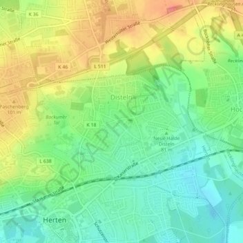
Name: Disteln topographic map, elevation, terrain.
Average elevation: 79 m
Minimum elevation: 49 m
Maximum elevation: 119 m
Make a donation
Gear up for your next adventure:
As an Amazon Associate, this site earns from qualifying purchases at no extra cost to you.
Other topographic maps
Click on a map to view its topography, its elevation and its terrain.
Halde Hoppenbruch
Deutschland > Nordrhein-Westfalen > Kreis Recklinghausen > Herten
Die Halde Hoppenbruch ist eine Bergehalde an der Straße Im Emscherbruch in Herten. Sie entstand zwischen 1978 und 1992 aus Aufschüttungen der Zechen Ewald/Schlägel & Eisen und General Blumenthal/Haard und hat ein Volumen von 34 Millionen Tonnen bei einer Höhe von etwas mehr als 70 Metern über dem…
Average elevation: 55 m