
Thank you for supporting this site ❤️
Make a donation
Make a donation
Gear up for your next adventure:
As an Amazon Associate, this site earns from qualifying purchases at no extra cost to you.
Geyersberg topographic map
Click on the map to display elevation.
Thank you for supporting this site ❤️
Make a donation
Make a donation
Gear up for your next adventure:
As an Amazon Associate, this site earns from qualifying purchases at no extra cost to you.
Geyersberg
Im Bereich der Ortslage befand sich ursprünglich mit dem Burgstall Geyersberg eine abgegangene mittelalterliche Höhenburg, die Sitz der Passauer Bischöfe war und sich in der Gegenwart unter Bodendenkmalschutz befindet.
Thank you for supporting this site ❤️
Make a donation
Make a donation
Gear up for your next adventure:
As an Amazon Associate, this site earns from qualifying purchases at no extra cost to you.
About this map
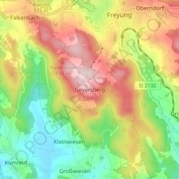
Name: Geyersberg topographic map, elevation, terrain.
Average elevation: 620 m
Minimum elevation: 474 m
Maximum elevation: 793 m
Thank you for supporting this site ❤️
Make a donation
Make a donation
Gear up for your next adventure:
As an Amazon Associate, this site earns from qualifying purchases at no extra cost to you.