
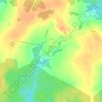
Лемы topographic map
Interactive map
Click on the map to display elevation.
About this map
Name: Лемы topographic map, elevation, terrain.
Average elevation: 163 m
Minimum elevation: 140 m
Maximum elevation: 178 m
Other topographic maps
Click on a map to view its topography, its elevation and its terrain.
Орловское
Россия > Удмуртия > Сюмсинский район
Орловское, Сюмсинский район, Удмуртия, Приволжский федеральный округ, Россия
Average elevation: 117 m
Сюмси
Россия > Удмуртия > Сюмсинский район
Сюмси, Сюмсинский район, Удмуртия, Приволжский федеральный округ, 427370, Россия
Average elevation: 129 m
Пумси
Россия > Удмуртия > Сюмсинский район
Пумси, Сюмсинский район, Удмуртия, Приволжский федеральный округ, Россия
Average elevation: 104 m
Зятцы
Россия > Удмуртия > Сюмсинский район
Зятцы, Сюмсинский район, Удмуртия, Приволжский федеральный округ, Россия
Average elevation: 158 m
Старый Кузлук
Россия > Удмуртия > Сюмсинский район
Старый Кузлук, Сюмсинский район, Удмуртия, Приволжский федеральный округ, Россия
Average elevation: 142 m
Берёзовка
Россия > Удмуртия > Сюмсинский район
Берёзовка, Сюмсинский район, Удмуртия, Приволжский федеральный округ, Россия
Average elevation: 135 m