Geolocate

Halcombe topographic map

Click on the map to display elevation.

About this map

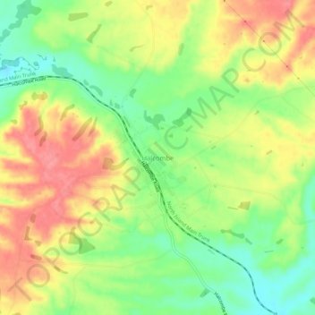
Name: Halcombe topographic map, elevation, terrain.

Location: Halcombe, Manawatū District, Manawatū-Whanganui, New Zealand (-40.16114 175.47392 -40.12114 175.51392)

Average elevation: 129 m

Minimum elevation: 87 m

Maximum elevation: 170 m

Other topographic maps

Click on a map to view its topography, its elevation and its terrain.

Gear up for your next adventure:

🧴Insect Repellent - Protect yourself from bugs during outdoor adventures
🥾Waterproof Hiking Boots - Essential footwear for rugged terrain and wet Canadian trails
🧦Hiking Liner Socks - Thin base layer to prevent friction and blisters
🛌Insulated Sleeping Pad - Critical thermal barrier between you and the cold ground
🧤Rechargeable Heated Gloves - Extreme warmth for Canadian winter expeditions

As an Amazon Associate, this site earns from qualifying purchases at no extra cost to you.