
Thank you for supporting this site ❤️
Make a donation
Make a donation
Gear up for your next adventure:
As an Amazon Associate, this site earns from qualifying purchases at no extra cost to you.
Hesselbach topographic map
Click on the map to display elevation.
Thank you for supporting this site ❤️
Make a donation
Make a donation
Gear up for your next adventure:
As an Amazon Associate, this site earns from qualifying purchases at no extra cost to you.
About this map
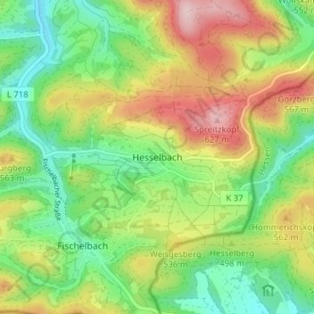
Name: Hesselbach topographic map, elevation, terrain.
Average elevation: 484 m
Minimum elevation: 379 m
Maximum elevation: 639 m
Thank you for supporting this site ❤️
Make a donation
Make a donation
Gear up for your next adventure:
As an Amazon Associate, this site earns from qualifying purchases at no extra cost to you.
Other topographic maps
Click on a map to view its topography, its elevation and its terrain.
57334
Deutschland > Nordrhein-Westfalen > Kreis Siegen-Wittgenstein > Bad Laasphe > Banfe
Average elevation: 500 m
Schloß Wittgenstein
Deutschland > Nordrhein-Westfalen > Kreis Siegen-Wittgenstein > Bad Laasphe > Laaspherhütte
Average elevation: 399 m