
Make a donation
Gear up for your next adventure:
As an Amazon Associate, this site earns from qualifying purchases at no extra cost to you.
Hobrechtsfelde topographic map
Click on the map to display elevation.
Make a donation
Gear up for your next adventure:
As an Amazon Associate, this site earns from qualifying purchases at no extra cost to you.
About this map
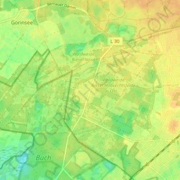
Name: Hobrechtsfelde topographic map, elevation, terrain.
Average elevation: 62 m
Minimum elevation: 45 m
Maximum elevation: 72 m
Make a donation
Gear up for your next adventure:
As an Amazon Associate, this site earns from qualifying purchases at no extra cost to you.
Other topographic maps
Click on a map to view its topography, its elevation and its terrain.
Schwanebeck
Deutschland > Brandenburg > Barnim > Panketal
In Schwanebeck befindet sich kein Bürgeramt der Gemeinde Panketal, da das Rathaus in Panketal nur rund vier Kilometer entfernt ist. – Für die Bekämpfung von Bränden und Hilfeleistungen nach besonderen Vorkommnissen gibt es die Schwanebecker Freiwillige Feuerwehr. Diese benötigt ein neues Feuerwehrhaus,…
Average elevation: 68 m