
Stoke Bruerne topographic map
Interactive map
Click on the map to display elevation.
About this map
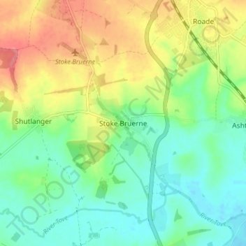
Name: Stoke Bruerne topographic map, elevation, terrain.
Average elevation: 98 m
Minimum elevation: 71 m
Maximum elevation: 141 m
Other topographic maps
Click on a map to view its topography, its elevation and its terrain.
Towcester
Royaume-Uni > Angleterre > West Northamptonshire
Towcester, West Northamptonshire, Angleterre, Royaume-Uni
Average elevation: 111 m
Northampton
Royaume-Uni > Angleterre > West Northamptonshire > Northampton
Northampton, West Northamptonshire, Angleterre, Royaume-Uni
Average elevation: 89 m