Geolocate

Orne topographic map

Click on the map to display elevation.

About this map

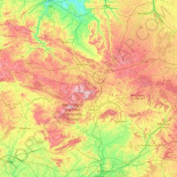
Name: Orne topographic map, elevation, terrain.

Location: Orne, Normandy, Metropolitan France, France (48.17939 -0.86055 48.97270 0.97661)

Average elevation: 164 m

Minimum elevation: 1 m

Maximum elevation: 424 m

Other topographic maps

Click on a map to view its topography, its elevation and its terrain.

La Sablonnière

France > Normandy > Calvados > Le Molay-Littry

Average elevation: 48 m

Villiers sur Port

France > Normandy > Calvados > Huppain

Average elevation: 35 m

Le Molay

France > Normandy > Calvados > Le Molay-Littry

Average elevation: 44 m

Gear up for your next adventure:

🧦Outdoor Socks - Durable socks designed for hiking and outdoor sports
Backpacking Tent - Lightweight tent for long-distance hiking trips
🧦Hiking Socks - Moisture-wicking and comfortable socks for long hikes
👖Convertible Hiking Pants - Zip-off legs to adapt to changing weather conditions
🧢Beanie Hat - Keep your head warm in cold weather

As an Amazon Associate, this site earns from qualifying purchases at no extra cost to you.