Geolocate

Bulabud topographic map

Click on the map to display elevation.

About this map

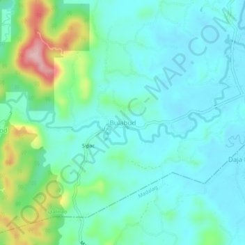
Name: Bulabud topographic map, elevation, terrain.

Location: Bulabud, Malinao, Aklan, Western Visayas, Philippines (11.55747 122.26010 11.59747 122.30010)

Average elevation: 65 m

Minimum elevation: 21 m

Maximum elevation: 220 m

Gear up for your next adventure:

🥾Hiking Leggings - Comfortable leggings for outdoor activities
🧼Travel Hand Sanitizer - Keep hands clean when water is scarce
🩹Moleskin Blister Pads - Direct protection for painful foot pressure points
🪑Ultralight Camping Stool - Compact seating for rest stops during long hikes
🔋Solar Power Bank - Keep your GPS and devices charged during long outdoor trips

As an Amazon Associate, this site earns from qualifying purchases at no extra cost to you.