
Make a donation
Gear up for your next adventure:
As an Amazon Associate, this site earns from qualifying purchases at no extra cost to you.
Gerabronn topographic map
Click on the map to display elevation.
Make a donation
Gear up for your next adventure:
As an Amazon Associate, this site earns from qualifying purchases at no extra cost to you.
Gerabronn
Die Stadt Gerabronn liegt in 422 bis 460 Meter Höhe auf einer Anhöhe in der Hohenloher Ebene. Das Stadtgebiet liegt in einer der größten Karstlandschaften Deutschlands und erstreckt sich über ein Höhenintervall von etwa 297 m ü. NHN am Ausfluss der Jagst bis hinauf zu etwa 491 m ü. NHN auf den Hochebenen. Es umfasst 48 Naturdenkmäler, u. a. einige Dolinen. Das Stadtgebiet wird von den beiden tief in die Hohenloher Ebene eingeschnittenen Flüssen Jagst und Brettach durchzogen, liegt aber überwiegend beidseits beider.
Make a donation
Gear up for your next adventure:
As an Amazon Associate, this site earns from qualifying purchases at no extra cost to you.
About this map
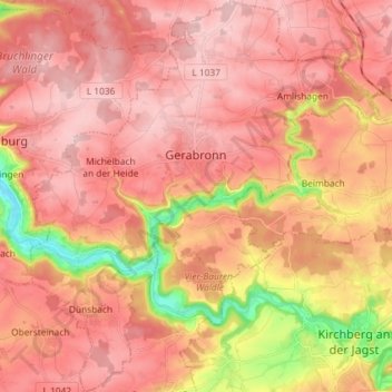
Name: Gerabronn topographic map, elevation, terrain.
Average elevation: 432 m
Minimum elevation: 293 m
Maximum elevation: 499 m
Make a donation
Gear up for your next adventure:
As an Amazon Associate, this site earns from qualifying purchases at no extra cost to you.
Other topographic maps
Click on a map to view its topography, its elevation and its terrain.
Einkorn
Deutschland > Baden-Württemberg > Landkreis Schwäbisch Hall > Schwäbisch Hall
Über eine Holztreppe, deren oberste Stufen innerhalb eines an der Nordostecke des Turms angebauten Scharwachtturms verlaufen, gelangt man zur überdachten Aussichtsplattform, die auf rund 25 m Höhe liegt. Von hier hat man einen weiten Blick über die Haller und Hohenloher Ebene und ins Kochertal hinunter.…
Average elevation: 412 m
Ramsbach
Deutschland > Baden-Württemberg > Landkreis Schwäbisch Hall > Schwäbisch Hall
Average elevation: 391 m
Make a donation
Gear up for your next adventure:
As an Amazon Associate, this site earns from qualifying purchases at no extra cost to you.
Brachbach
Deutschland > Baden-Württemberg > Landkreis Schwäbisch Hall > Übrigshausen
Average elevation: 393 m
Hessental
Deutschland > Baden-Württemberg > Landkreis Schwäbisch Hall > Schwäbisch Hall
Stadtmitte | Nördliche Kernstadt | Kreuzäcker | Südliche Kernstadt | Tullauer Höhe / Hagenbach | Rollhof / Reifenhof | Stadtheide | Heimbachsiedlung / Teurershof | Steinbach | Hessental | Bibersfeld | Gailenkirchen | Gelbingen | Eltershofen | Sulzdorf | Tüngental | Weckrieden
Average elevation: 394 m