
Make a donation
Gear up for your next adventure:
As an Amazon Associate, this site earns from qualifying purchases at no extra cost to you.
Rocky Bottom topographic map
Click on the map to display elevation.
Make a donation
Gear up for your next adventure:
As an Amazon Associate, this site earns from qualifying purchases at no extra cost to you.
About this map
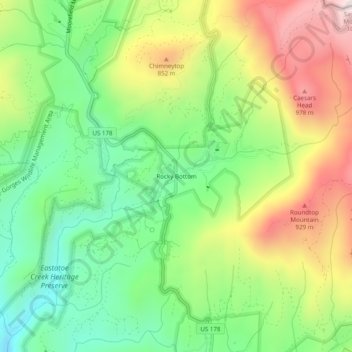
Name: Rocky Bottom topographic map, elevation, terrain.
Location: Rocky Bottom, Pickens County, South Carolina, United States (35.02595 -82.82236 35.06595 -82.78236)
Average elevation: 651 m
Minimum elevation: 367 m
Maximum elevation: 1,058 m
Make a donation
Gear up for your next adventure:
As an Amazon Associate, this site earns from qualifying purchases at no extra cost to you.
Other topographic maps
Click on a map to view its topography, its elevation and its terrain.
Jocassee Gorges Wildlife Management Area
United States > South Carolina > Pickens County
Average elevation: 526 m
Make a donation
Gear up for your next adventure:
As an Amazon Associate, this site earns from qualifying purchases at no extra cost to you.