
Thank you for supporting this site ❤️
Make a donation
Make a donation
Gear up for your next adventure:
As an Amazon Associate, this site earns from qualifying purchases at no extra cost to you.
Chichis topographic map
Click on the map to display elevation.
Thank you for supporting this site ❤️
Make a donation
Make a donation
Gear up for your next adventure:
As an Amazon Associate, this site earns from qualifying purchases at no extra cost to you.
About this map
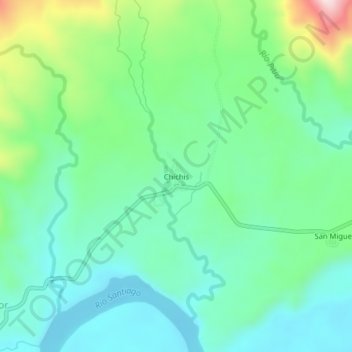
Name: Chichis topographic map, elevation, terrain.
Location: Chichis, Santiago, Tiwintza, Morona Santiago, Ecuador (-3.04072 -77.99126 -3.00072 -77.95126)
Average elevation: 342 m
Minimum elevation: 238 m
Maximum elevation: 625 m
Thank you for supporting this site ❤️
Make a donation
Make a donation
Gear up for your next adventure:
As an Amazon Associate, this site earns from qualifying purchases at no extra cost to you.