
Make a donation
Gear up for your next adventure:
As an Amazon Associate, this site earns from qualifying purchases at no extra cost to you.
Sint-Jozef-Olen topographic map
Click on the map to display elevation.
Make a donation
Gear up for your next adventure:
As an Amazon Associate, this site earns from qualifying purchases at no extra cost to you.
Sint-Jozef-Olen
Sint-Jozef-Olen ligt ten zuiden van het Kanaal Bocholt-Herentals op een hoogte van ongeveer 18 meter. Ten noorden van het kanaal, en min of meer parallel daarmee, loopt de Kleine Nete. Een natuurgebied in de vallei van de Kleine Nete is het Olens Broek en Langendonk.
Make a donation
Gear up for your next adventure:
As an Amazon Associate, this site earns from qualifying purchases at no extra cost to you.
About this map
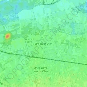
Name: Sint-Jozef-Olen topographic map, elevation, terrain.
Average elevation: 16 m
Minimum elevation: 5 m
Maximum elevation: 41 m
Make a donation
Gear up for your next adventure:
As an Amazon Associate, this site earns from qualifying purchases at no extra cost to you.