
Ardrossan topographic map
Interactive map
Click on the map to display elevation.
About this map
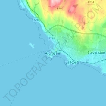
Name: Ardrossan topographic map, elevation, terrain.
Location: Ardrossan, North Ayrshire, Scotland, KA22 8BS, United Kingdom (55.60005 -4.85486 55.68005 -4.77486)
Average elevation: 21 m
Minimum elevation: -1 m
Maximum elevation: 174 m
Other topographic maps
Click on a map to view its topography, its elevation and its terrain.
Millhill
United Kingdom > Scotland > North Ayrshire
Millhill, North Ayrshire, Scotland, KA27 8HQ, United Kingdom
Average elevation: 163 m
Stevenston
United Kingdom > Scotland > North Ayrshire > Stevenston
Stevenston, North Ayrshire, Scotland, KA20 3HE, United Kingdom
Average elevation: 27 m