
Vacoas-Phœnix topographic map
Interactive map
Click on the map to display elevation.
About this map
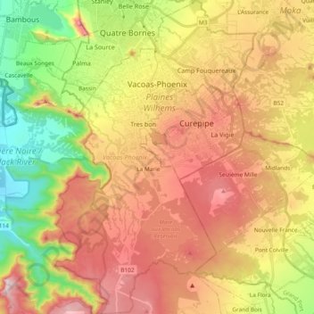
Name: Vacoas-Phœnix topographic map, elevation, terrain.
Location: Vacoas-Phœnix, Plaines Wilhems, Maurice (-20.42155 57.43706 -20.24663 57.55680)
Average elevation: 424 m
Minimum elevation: 37 m
Maximum elevation: 812 m
Other topographic maps
Click on a map to view its topography, its elevation and its terrain.
Quatre Bornes
Maurice > Plaines Wilhems > Quatre Bornes
Quatre Bornes, Plaines Wilhems, 72208, Maurice
Average elevation: 224 m
Vacoas-Phoenix
Maurice > Plaines Wilhems > Vacoas-Phoenix
Vacoas-Phoenix, Plaines Wilhems, 73240, Maurice
Average elevation: 259 m
Curepipe
Maurice > Plaines Wilhems > Curepipe
Curepipe, Plaines Wilhems, 74321, Maurice
Average elevation: 278 m