
Make a donation
Gear up for your next adventure:
As an Amazon Associate, this site earns from qualifying purchases at no extra cost to you.
Maria Helena topographic map
Click on the map to display elevation.
Make a donation
Gear up for your next adventure:
As an Amazon Associate, this site earns from qualifying purchases at no extra cost to you.
Maria Helena
Localiza-se na Região Metropolitana de Umuarama, nas seguintes coordenadas geográficas: Latitude: 23°35’30” SUL e Longitude: 53°12’ W – GR. Fica a 592,79 km de distância da capital, com uma altitude de 630m acima do nível do mar.
Make a donation
Gear up for your next adventure:
As an Amazon Associate, this site earns from qualifying purchases at no extra cost to you.
About this map
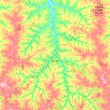
Name: Maria Helena topographic map, elevation, terrain.
Average elevation: 377 m
Minimum elevation: 271 m
Maximum elevation: 499 m
Make a donation
Gear up for your next adventure:
As an Amazon Associate, this site earns from qualifying purchases at no extra cost to you.
Other topographic maps
Click on a map to view its topography, its elevation and its terrain.
Reserva Biológica das Perobas
Brasil > Paraná > Região Metropolitana de Umuarama > Cianorte
Average elevation: 508 m
Make a donation
Gear up for your next adventure:
As an Amazon Associate, this site earns from qualifying purchases at no extra cost to you.
Caramuru
Brasil > Paraná > Região Metropolitana de Umuarama > São Jorge do Patrocínio
Average elevation: 298 m
Serra dos Dourados
Brasil > Paraná > Região Metropolitana de Umuarama > Umuarama
Average elevation: 426 m
Make a donation
Gear up for your next adventure:
As an Amazon Associate, this site earns from qualifying purchases at no extra cost to you.
Make a donation
Gear up for your next adventure:
As an Amazon Associate, this site earns from qualifying purchases at no extra cost to you.