Geolocate

Benfleet topographic map

Click on the map to display elevation.

About this map

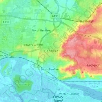
Name: Benfleet topographic map, elevation, terrain.

Location: Benfleet, Castle Point, Essex, England, SS7 5SW, United Kingdom (51.52495 0.51582 51.60495 0.59582)

Average elevation: 25 m

Minimum elevation: -3 m

Maximum elevation: 87 m

Gear up for your next adventure:

🪑Ultralight Camping Stool - Compact seating for rest stops during long hikes
🦶Hiking Shoe Insoles - Added support for high arches and long days on feet
🛶Kayak Dry Bag - Waterproof storage for kayaking adventures
🌡️Emergency Mylar Blankets - Compact thermal protection for unexpected nights outdoors
🦯Trekking Poles - Reduced impact on joints for steep topographic climbs

As an Amazon Associate, this site earns from qualifying purchases at no extra cost to you.